Geo: Volcanic islands past & present
2004 was the deadliest year for earthquakes since the Renaissance Age, according to the United States Geological Survey. The Indian Ocean tsunamis proved deadlier than any natural disaster since 1556, leading many to wonder if the earth has somehow become unbalanced, or if what we are witnessing is nature gone wild.
Look across deep time, however, and the events of last December can be seen as part of immensely slow geological processes that have gone on for billions of years. "An earthquake of this magnitude, in this part of the world, has probably occurred about a million times [in the last two hundred million years]," Christopher Scotese, a geophysicist at the University of Texas-Arlington, told CNN.
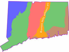
In Connecticut, geologists have described an area of bedrock that suggests similar sorts of earthquakes may have also occurred during the time eastern North America was being stitched together, nearly half a billion years ago.
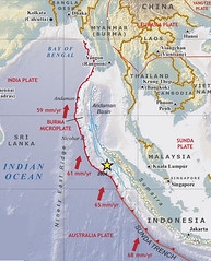
The cause of the Indian Ocean tsunamis was a "megathrust" event, where a portion of the earth's crust known as the Indian Plate slipped along and under an adjoining portion of crust known as the Burma Plate. The forces involved in these "oceanic-oceanic" convergences are immense. This most recent megathrust caused an earthquake deep beneath the Indian Ocean, generating massive waves that quickly spread hundreds across hundreds of miles of its surface.
Studies of the area reveal a deep oceanic trench, called the Sunda Trench, that marks a boundary where the Indian and Burma plates converge, forcing the Indian plate beneath, and into the earth's core. Adjacent is a string of volcanic islands, the island arc of Sumatra, formed as the tremendous heat and pressure of plate collisions press molten rock up to the surface.
 .
.Look at the Bedrock Geologic Map of Connecticut and an area thought to be the remains of an ancient volcanic island arc can be seen just east of the Hartford Basin, the state's central lowlands. Known as the Bronson Hills, these islands are thought to have been formed as oceanic plates beneath a former ocean, Iapetus, converged perhaps a half a billion years ago.
Most of the state today is made up of what was once the seafloor beneath Iapetus, long since metamorphosed into gneiss and schist as the ocean narrowed and eventually closed. In between is another area of gneiss and schist believed to have been formed by the metamorposis of the Bronson Hills island arc.
 .
.We will never know exactly what occurred during the time North America and our region were formed, but we are able to form a picture from events such as the tragedy of the Indian Ocean earthquake and tsunamis. It was the renowned geologist James Hutton who saw the present as the key to understanding the geologic past, and that insight still guides much of geological science today.
posted by Brendan Hanrahan @ 2/25/2005 05:37:00 PM
0 comments
![]()
![]()
0 Comments:
Post a Comment
<< Home