Monday, February 28, 2005

Eco: Ice, sea and sand

We think of beaches as summer places, but a trip to the coast in winter promises its own rewards. I went with the boys to the Connecticut Audubon Coastal Center at Milford Point recently. We spent hours on the sandbar, chasing floating ice and poring over shells and old bits of horseshoe crabs.

After a cold wind forced us to retreat, we walked to the Center’s main building. Before going in, we climbed the tower at the corner to view two of Connecticut’s “critical habitats,” the tidal marsh to the west, and sandy beach to the east.


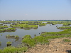
The Center is located between the beach of the Smith-Hubbell Wildlife Refuge and the tidal marsh of the Wheeler Wildlife Management Area, where the Housatonic River runs into the Long Island Sound, in Milford.

Shotgun blasts revealed hunters braving the cold in a small boat while (we imagined) they dreamed of duck for dinner. We headed inside, where the view through the bank of windows is nearly as spectacular, and where it is warm.

Tidal marshes are fragile places, where land and sea meet. On cold days it’s easy to imagine how they formed following the last Ice Age, and to see the threat that the homes, towers and stacks looming in the distance pose to their future.

During the ice advance of 20,000 years ago, the sea was lower and further out, some 70 miles south of Long Island. As the glacier retreated, water once locked in ice contributed to a rise in sea level that over thousands of years flooded the Atlantic coastal plain and “drowned” its river valleys.

Connecticut College Professor R. Scott Warren described how tidal marshes formed. “As the waters of Long Island Sound flooded coastal uplands they moved the shoreline inland, a process termed ‘marine transgression.’ Drowned coastal river valleys are our present day coves and tidal marshes.”

Grasses colonized coastal areas that filled with sediments. Plant remains accumulated as peat. Complex living communities arose, according to their elevation above the sea. Today, our marshes support a web of life—plankton, marine animals, birds, reptiles and mammals—in part due to tides that bring minerals and nutrients twice daily.

But, sea levels are on the rise again, at rates that now threaten to overwhelm our marshes. In the past, the marshes could move inland with the coastline. Today, there are buildings and highways in the way. As a result, tidal marshes are declining and in areas such as Greenwich, may soon disappear altogether.

Friday, February 25, 2005

Eco: Death of Environmentalism exaggerated

“We have become convinced that modern environmentalism, with all of its…outdated concepts and exhausted strategies, must die so that something new can live,” write pollsters Michael Shellenberger and Ted Nordhaus. (New York Times, February 6, 2005).

Similar to the way “ecological release” enables new forms of life to prosper from the extinction of the more primitive, their recent paper, “The Death of Environmentalism,” amounts to a call for the “political release” of environmental activism.

It’s a message that can be hard to hear, particularly among those who have given so much to conservation causes. Others see the value of retrospection. Adam Werbach, a former Sierra Club national president, has opened speeches by telling audiences, “I’m here to perform an autopsy.”

One would hope that before an autopsy is required every effort would be made to see what is ailing the patient. If the environmental movement has lost its way—and it’s hard to describe current declines in biodiversity as anything but a dismal failure—it has done so by walking away from its roots, or rather its grassroots.

In Connecticut, more and more municipalities are struggling to manage issues surrounding the pace of development, wetland protections, open space preservation, and more. Too often, administrators feel outmatched and isolated, when in fact there is a great deal of valuable information, and public resources available to assist them.

The real, immediate problem we face is organizing at the local level to assist people to make the ordinary, day-to-day decisions that could lead to real change, and improve our quality of life in the future.

Two who are in the trenches everyday, working with Connecticut towns and their administrators to empower them to represent communities’ interests, are Dr. Michael Klemens of the Metropolitan Conservation Alliance (MCA) of the Wildlife Conservation Society, and Roman Mrozinski, Executive Director of the Southwest Conservation District.

Klemens ideas are straightforward and powerful, and in some cases even promise to save money. He advocates that towns make time to imagine the places they want to become in the future, plan accordingly, and pass local regulations that will enable them to negotiate successfully with large developers and their legal teams, who have the know-how to leverage every angle.

Mrozinski works with organizations such as MCA and the Connecticut DEP to organize workshops to train town administrators in planning techniques, and regularly drives throughout his district to assist in key environmental issues.

Together, they are promoting a vision for community planning that can support development and protect biodiversity at the local level. It’s exactly the sort of new thinking that needs to see the light of day.

Eco: Bewitched, bothered and Bog-gled

If you ask me there is no better spur of the moment, get out and feel the bite of crisp late winter air field trip than a visit to a Connecticut black spruce bog.

.

We visited the black spruce bog in the Mohawk State Forest in Goshen with the boys on a cold, snowy day, a wonderful time to be there. A plank walk leads into the heart of the bog, a magical place made even more mystical with its carpet of moss and ferns and majestic spruce trees draped in snow and frost.

Bogs, like swamps are among the many gifts the Laurentide Ice Sheet left for us after the last glaciation of some 20,000 years ago, but their vegetative mats grow to extend out over wetlands that fill glacial depressions. They may fill in entirely in just the next 5,000 years, so you need to get out to see them while they last.

Geo: Volcanic islands past & present

2004 was the deadliest year for earthquakes since the Renaissance Age, according to the United States Geological Survey. The Indian Ocean tsunamis proved deadlier than any natural disaster since 1556, leading many to wonder if the earth has somehow become unbalanced, or if what we are witnessing is nature gone wild.

Look across deep time, however, and the events of last December can be seen as part of immensely slow geological processes that have gone on for billions of years. "An earthquake of this magnitude, in this part of the world, has probably occurred about a million times [in the last two hundred million years]," Christopher Scotese, a geophysicist at the University of Texas-Arlington, told CNN.

In Connecticut, geologists have described an area of bedrock that suggests similar sorts of earthquakes may have also occurred during the time eastern North America was being stitched together, nearly half a billion years ago.

The cause of the Indian Ocean tsunamis was a "megathrust" event, where a portion of the earth's crust known as the Indian Plate slipped along and under an adjoining portion of crust known as the Burma Plate. The forces involved in these "oceanic-oceanic" convergences are immense. This most recent megathrust caused an earthquake deep beneath the Indian Ocean, generating massive waves that quickly spread hundreds across hundreds of miles of its surface.

Studies of the area reveal a deep oceanic trench, called the Sunda Trench, that marks a boundary where the Indian and Burma plates converge, forcing the Indian plate beneath, and into the earth's core. Adjacent is a string of volcanic islands, the island arc of Sumatra, formed as the tremendous heat and pressure of plate collisions press molten rock up to the surface.

.

Look at the Bedrock Geologic Map of Connecticut and an area thought to be the remains of an ancient volcanic island arc can be seen just east of the Hartford Basin, the state's central lowlands. Known as the Bronson Hills, these islands are thought to have been formed as oceanic plates beneath a former ocean, Iapetus, converged perhaps a half a billion years ago.

Most of the state today is made up of what was once the seafloor beneath Iapetus, long since metamorphosed into gneiss and schist as the ocean narrowed and eventually closed. In between is another area of gneiss and schist believed to have been formed by the metamorposis of the Bronson Hills island arc.

.

We will never know exactly what occurred during the time North America and our region were formed, but we are able to form a picture from events such as the tragedy of the Indian Ocean earthquake and tsunamis. It was the renowned geologist James Hutton who saw the present as the key to understanding the geologic past, and that insight still guides much of geological science today.

Thursday, February 24, 2005

Paleo: You say prosauropod; I say sauropod…

There are few places in the world where a few fragmentary pieces of dinosaur bones could command constant scrutiny for nearly two centuries. The Connecticut Valley is one of those places, and the bones of a small plant-eating dinosaur found here, logged in the Yale Peabody Museum collection as catalog number YPM 2125, are such bones.

Their true nature has been the subject of much debate from the time the bones were first discovered, during blasting for a well in East Windsor, Connecticut in 1818, right up until the present. They were found decades before dinosaurs were even known, and there was doubt at first as to whether the bones were animal or human.

The first accounts were published by Benjamin Silliman, a pioneer of geology in the New World, in his "American Journal of Science." Other descriptions and mentions continued to be published in the 1830s, 40s, and 50s, by such renowned scholars as Rev. Edward Hitchcock and Dr. Jeffries Wyman.


It wasn’t until 1896 that the infamous bone hunter, O. C. Marsh, first declared “the Bones from the Well” to be dinosaurian—presumably a prosauropod similar to specimens of Anchisaurus and Ammosaurus Marsh collected from the Wolcott Quarry in Manchester, in an area that today includes the Buckland Hills Mall.

Early in the 20th century, the renowned paleontologist Richard Swann Lull made his own careful appraisals of “the Bones from the Well.” University of Bridgeport paleontologist Peter Galton published the findings of studies he made of the bones in the 1970s.

All reached a similar conclusion, that the bones listed as YPM 2125 were those of a prosauropod, an early form of plant-eater that was among the first to develop a body type later perfected by the huge sauropod dinosaurs of Late Jurassic time, beasts such as the giant Apatosaurus seen today in the Great Hall at the Peabody.

That was until British paleontologist Adam Yates published the newest in the long line of studies of “the Bones from the Well” in April of 2004. Yates argued that YPM 2125 wasn’t a prosauropod after all, but one of the earliest known of the sauropod dinosaurs instead.

The bones survive today as little more than chalky smudges in blocks of Connecticut Valley brownstone. While the debate as to their true nature still rages, one thing is for sure. The specimen Silliman marked with the initials “B.S.” nearly two centuries ago stand today as “the earliest verifiable discovery of dinosaur bones in North America.”

Geo: Come Together

Is there another supercontinent—Pangaea Ultima—in our future? Christopher Scotese of the University of Texas at Austin is one geologist who thinks there is.

Connecticut was once smack in the middle of a vast former landmass known as Pangaea, when all of the world's continents were compressed together. Our central “rift” valley contains a record of a period of tumult that resulted as Pangaea later stretched and broke apart, over 200 million years ago.

New models of the motion of the earth’s plates suggest the continents are now slowing coming back together. Over the past tens of millions of years, Africa has migrated into Europe, raising the Alps and the Pyrenees, causing tremors from Italy to Turkey and compressing the Mediterranean to a fraction of its former size. Even Australia’s days as an isolated fragment of crust seem to be numbered, as it heads north toward Asia.

Scotese, renowned for the maps he has constructed of the earth in the deep past, can imagine a time, 250 million years in the future, when the movements of continental crust will assemble a new supercontinent, one he has dubbed "Pangaea Ultima." No word yet on what the effect may be on real estate values.

Fish: Get 'em while they're cold

Trout are at their best in cold water—and our rivers and lakes aren’t likely to get much colder than they will be come opening day, the third Saturday in April, which this year is April 16th.

.

Can’t wait till then? Make a visit to a state trout hatchery. It’s a great way to shake off winter and get the kids ready for your first trip. The Burlington Trout Hatchery is located on Belden Road, off Route 4, across from the Town Hall in Burlington, CT. Phone: (860) 673-2340; Hours: Daily 8:00 am to 3:30 pm. Admission is free. The Quinebaug Valley Trout Hatchery is one of the largest in the East, producing over 300,000 pounds of trout each year. It’s located on Trout Hatchery Road, Central Village, CT. Phone: (860) 564-7542; Hours: Daily 9:30-3:30. Admission is free.

It’s never too early to visit the CT DEP Fisheries Division web site, and look over this year’s regulations and start thinking about how to make the most of warm weather fishing. This year’s Angler’s Guide can be downloaded in pdf format.

Once April 16th finally does roll around, think about taking the kids to one of the many Trout Parks, lakes around the state that the Fisheries Division keeps well stocked to tilt the odds in your favor and make sure no one goes home without their own fish story to tell.