Thursday, September 22, 2005

Paleo: New dinosaur found in New Haven

A dinosaur not seen in 66 million years turned up on Whitney Avenue in New Haven today. Workers took advantage of the beautiful fall weather to install a newly created bronze sculpture of Torosaurus Iatus in front of the Yale Peabody Museum of Natural History. Torosaurus was a ceratopsian, a group of horned and frilled dinosaurs that included Triceratops, and lived in the Late Cretaceous, practically at the end of the Age of Dinosaurs.


Built with a beak like a pruning shear, powerfully muscled jaws, and shearing teeth (like giant scissors), Torosaurus incorporated design improvements made to plant eating dinosaurs over 160 million years. By comparison, plant eating dinosaurs known from Connecticut Valley fossil bones, such as Anchisaurus, or footprints such as Anomoepus, were far more primitive. Connecticut's dinosaurs were early models, from much earlier in the Age of Dinosaurs than Torosaurus.

The Torosaurus sculpture was created by Peabody Museum Preparator Michael Anderson who examined Torosaurus bones from the Peabody collections, consulted with experts at the Peabody and Smithsonian, as well as other institutions, and used computer animation to complete the project. Anderson produced models and a wax prototype that were used to cast the final sculpture in bronze. It is 9 feet tall and 21 feet long and took nearly five years to complete. It was made possible through the generosity of Elizabeth R. and Stanford N. Phelps and their grandchildren Max, Garrett and Ford.


Artist Michael Anderson (yellow shirt) watches as the dinosaur he created is lowered onto a specially built granite foundation. Photos by Yale Peabody Museum herpetologist Greg Watkins-Colwell.

The Torosaurus will remain wrapped up under a tarp for the next several weeks while the final installation is completed. The cover comes off during the official unveiling scheduled for Saturday, October 22, from 10:00 am to 4:00 pm. Yale paleontologist and Museum Assistant Dan Brinkman, one of the dinosaur scientists at the Peabody Museum who was a scientific consultant on the project, will be on hand following the unveiling to discuss Torosaurus fossil discoveries and the scientists who made them.

Wednesday, September 21, 2005

Geology, Hurricanes and the Floods of '55

This year's catastrophic hurricane season brings back memories of 1955 for many who survived the floods that hit Connecticut during late summer a half century ago. On August 12 & 13, Hurricane Connie brought 8 inches of rain. On the 18th, Hurricane Diane brought more. The Hartford Courant reported “normally docile brooks were transformed into menacing monsters by relentless rain." The ground saturated by Connie, Diane caught people by surprise.

In a little over 24 hours, more than a foot of rain fell in Connecticut and Massachusetts. Rivers, streams, lakes and ponds spilled over, sending torrents of water through towns. A state record 14.25 inches fell in Torrington; Westfield, MA had nearly 20 inches. By the afternoon of Aug. 19, the storm passed. 87 people died, communities were wrecked, and losses were hundreds of millions of dollars.

The geology and hydrology of Connecticut show how the storms led to a catastrophe. The landscape has a decidedly north-south grain that goes back to continental collisions in the deep past. Since then, it's been water, flowing south toward the Atlantic, that has shaped local hills and valleys.


Today, the state's three major rivers, the Housatonic, Connecticut and Thames, are the primary watercourses that carry runoff to the Long Island Sound. They are fed by a great many smaller streams and rivers that drain upland areas across the northern two-thirds of the state.


Water gathers into bigger and bigger watercourses as it rolls downhill. In Connecticut, water streams down along erosional planes that slope to the Atlantic, as it has done for perhaps millions of years. Along the way, it gains speed, volume, and power. The volume of water that fell in August 1955 quickly exceeded the rivers' natural capacities, and the power of the runoff grew to be tremendous.


Nearer the shore, areas surrounding many shorter rivers were also affected. Along the southern third of the state, these shorter rivers drain an area referred to as the coastal plain. In many cases, these are also fed by adjoining streams and smaller rivers, and the effects of the flash floods on these watercourses were similar.

In most years, the state's streams and rivers work as an efficient natural drainage system, carved out over large spans of geological time. There are times, however, when the nature of Connecticut's watercourses leaves the possibility that they can be overwhelmed by extreme weather such as hurricanes and flash floods.

Controls such as the many dams that have been built since 1955 have been designed to provide greater protection and limit damage. According to the Army Corps of Engineers, these dams can be used to better control water flows. Forecasting and our knowledge of how hurricanes behave has also improved.

Yet, these improvements have still to be tested by a series of storms, back to back, as occurred fifty years ago. The geology and hydrology of Connecticut remains largely as it was, and damaging hurricanes can be expected to hit the state at least every hundred years or so. While many see a repeat of anything like what occurred in 1955 as unlikely, only one thing is for sure. There's no way to know what Mother Nature may have up her sleeve next.

Saturday, September 17, 2005

Hammonassett Festival '05

Hammonassett Beach State Park is always a wonderful place to visit, and the weekend of October 8th & 9th promises to be one of the best times of the year to head to Madison and check it out. October brings spectacular beach days and the park's annual festival.


The upcoming Hammonasset Festival 2005, put together by the Friends of Hammonassett organization, will offer programs and nature walks sure to delight families, and beach lovers. On the weekend of Oct. 8th & 9th, the festival will celebrate nature and Native Americans with a demonstration archaeology dig, birds of prey and primitive technologies programs, fly tying and casting demos, lectures on geology, turquoise and wampum and coastal ecology, museum exhibits, guided nature walks, storytelling and children's nature activities, traditional food and other refreshments.

Programs and performances will feature Kenny Merrick Jr. & the Mystic River Singers, Joseph Fire Crow (flute), CT State Archaeologist Nicholas Bellantoni, WINGMASTERS live birds of prey, Trout Unlimited, the Mashantucket Pequot Museum, the Institute for American Indian Studies, and the Yale Peabody Museum of Natural History.

Come and enjoy the festival—rain or shine!

Admission is $5, children under 10 are free. For more information, call (203) 318-0517, ext. 217, or email to info@hammonassett.org. Hammonassett Beach State Park is in Madison, CT, exit 62 off I-95.

Monday, September 12, 2005

The Cambrian Explosion—in the Farmington River?

More than 500 million years ago, life on earth suddenly took a great leap forward. During the time known as the "Cambrian Explosion," multicellular life underwent a rapid expansion. The renowned Burgess Shale fossils record this as a period when many of the major groups of animals first appeared, including invertebrates such as corals, sea anenomes, sea stars, jellyfish, and soon after, bryozoans.

The bryozoan colony that herpetologist Brian Kleinman pointed out during a canoe trip on the Farmington River on Sunday was so strange looking I couldn't help but wonder if it wasn't some alien invader, or a disembodied brain, like one Dr. Frankenstein's assistant Igor might have dropped after robbing a medical school cadaver.


Brian Kleinman holds the bryozoan colony he found in a mucky channel along the banks of the Farmington River.

In fact, it was an ancient form of life rooted in the deep past, when much of the world would have been unrecognizable to us today. Where the river spilled into an impoundment was an example of one of the few freshwater species of bryozoan, Pectinatella magnifica.

Around the outside of this gelatinous colony, we saw what must have been hundreds of smaller rosettes, each comprised of a dozen or more individual animals. The inner area is filled with water that can be forced out with a gentle squeeze. Each animal has tentacles and beating cilia it uses to filter food particles suspended in the river's turbid waters and move them into its mouth.

"I love them," says Marcy Klattenberg, an ecologist and earth science teacher in Durham. "They can grow to over 12 inches across and include thousand of individual animals. This is the time of year when the colonies will soon form statoblasts [nodules or buds], which will then fall off and drift to the bottom where they will overwinter before growing into a new colony next spring."

As strange and primitive as they are, bryozoans like those found in Connecticut rivers, or the salt water of Long Island Sound, offer clues to a very different world, when life began its first great expansion some 500 million years ago.

Saturday, September 03, 2005

Eco: CT tidal marshes, good as gold

The Hurricane Katrina disaster shows a need for municipalities to weigh short-term gains to be had by developing areas such as wetlands against the long-term benefits of a healthy environment.

The NY Times reported that the development of ports in the Mississippi Delta led to declines in marshes there, and a loss of natural flood controls. “People realized what a terrible bargain the region made when it embraced environmental degradation for economic gains.” (NYT, 8/30/05). The report, and another on CNN.com, echoed a 2004 National Geographic story about marsh losses in the Louisiana bayou.

That coastal wetland development comes at a price is an old story—with its own history in Connecticut. “[CT tidal] marshes have been viewed as expendable,” Richard Goodwin, of the Connecticut College Arboretum, wrote in 1961. “If the public recognized these areas as resources of importance to our welfare their destruction would be curtailed.” On Saturday, the boys and I walked the length of what remains of the tidal marsh at Sherwood Island State Park, along East Beach to the inlet, to explore the issues Goodwin wrote about.

In 1961, Connecticut tidal marshes were also in rapid decline. Practices such as the dumping of millions of cubic yards of construction fill, as was done to add parking at Sherwood Island State Park in 1956, obliterated CT marshes at a rate Goodwin projected would destroy 86% of them by 2000. (CT’s Coastal Marshes, CT College Arboretum, No. 12, 1961).


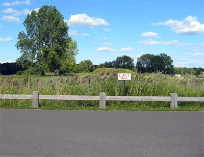
The view toward the marsh from the lot where we parked, atop 3.5 million cubic yards of fill. The parking lot replaced much of what was then the last publicly owned marsh west of the Housatonic, a wetland once enjoyed by kids, birders, crabbers and duck hunters, and that fed valuable seed oyster beds, clam beds and fisheries offshore.

An estimate by CT DEP found that between 1880 and 1970, the State lost an average 70 acres of tidal wetland per year, at times as much as an acre a day. At least a third, and perhaps as much as half, of all CT tidal wetlands were drained or filled. Stamford, Fairfield, Bridgeport, Stratford, New Haven and New London lost 60% of the marshes within their borders. (Wetlands of CT, CT State G&NH Survey, 1992. Tidal Marshes of LIS, CT College Arboretum, No. 34, 1995).


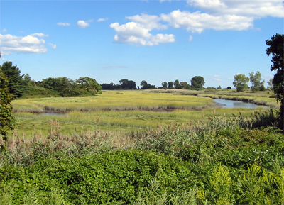
A view of the portion of the original tidal marsh that remains at Sherwood Island today. Out of frame to the left (but not out of earshot) are the Metro North railroad, and the CT turnpike (I-95).

Today, Goodwin's 1961 publication marks a turning point in the destruction of CT tidal marshes. His vision of protective acquisitions, controls, zoning changes, and education has since been enacted to stem declines. Some 17,500 acres of CT tidal marsh are now preserved, by legislation such as the CT Tidal Wetlands Act of 1969, the creation of national preserves such as the Salt Meadow and McKinney Refuges, the State's purchase of as much as 30% of tidal marsh areas, and the launch of the DEP restoration program in '92. Many municipalities and private trusts now also protect marsh areas.

The publication also marked a change in the economic value placed on wetlands in general. In 1992, the CT DEP published an itemized list of the values of wetlands (Wetlands of CT, CT G&NH Survey, 1992). These include resources such as fish and shellfish habitat, waterfowl and endangered wildlife habitat, environmental quality values such as water quality improvement and aquatic productivity, and socio-economic values such as flood and storm damage protection, erosion control, harvest of natural products, recreation and aesthetics.

CT's experience over the past 40 years might now be useful for estimating the economic cost of marsh destruction in the Mississippi Delta. There are fundamental differences. The Mississippi feeds freshwater marshes; tidal marshes in CT are governed by the ebb and flow of the sea. Yet, both have both environmental and economic value far too costly to overlook.


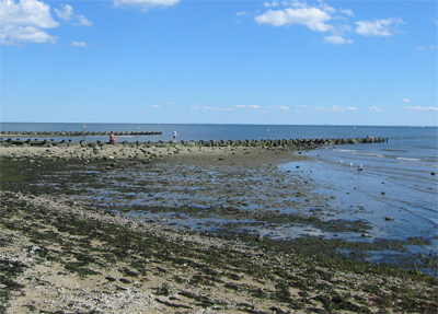
A view of the jetties beside the inlet to the tidal marsh at East Beach, Sherwood Island State Park, Westport.

Of course, with protection comes responsibility. There is more to do. The '95 CT DEP wetlands report notes that "coastal intertidal flats have not received the same protection, with tens of acres still dredged each year. Although tidal wetlands laws have been enacted to 'protect' coastal wetlands, stronger regulations are necessary to preserve all remaining tidal wetlands and mudflats for generations to come."


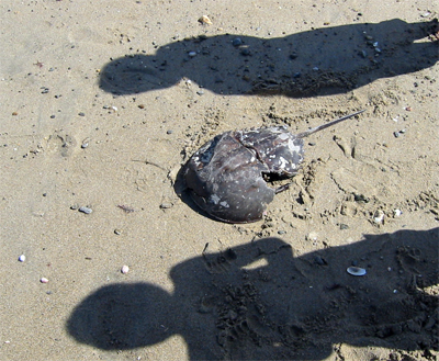
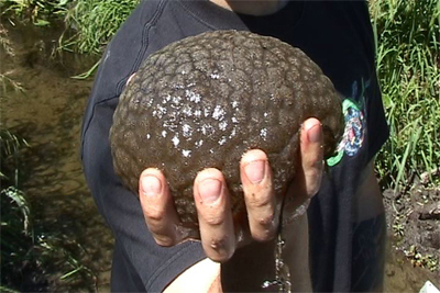
A large horseshoe crab shell the boys and I found along East Beach on our way to the jetties.

Want to dip a toe in the water? Try participating in one of the beach cleanups being organized by Save the Sound this month. They have posted a list of scheduled cleanups by town, up and down the shore. It's a great way to extend your summer beach season, and to teach kids to care for areas such as tidal marshes.